EXPLICIT, IMPLICIT AND AI-BASED MODELING IN GEOLOGY: COMPARATIVE ANALYSIS AND INTEGRATION PROSPECTS
DOI:
https://doi.org/10.30970/vgl.40.09Keywords:
geological modeling, explicit modeling, implicit modeling, artificial intelligence, AI-based modeling, three-dimensional geological models, geological data interpretation, mineral deposit modelingAbstract
Geological 3D modeling is one of the key stages in the interpretation of geophysical and geological data, enabling the creation of a three-dimensional representation of deposit structure, the size and depth of geological bodies, and the patterns of mineral distribution. In the context of rapid digitalization and the growing volume of geoscientific data, there is an increasing need to compare traditional and modern modeling approaches, particularly in terms of their effectiveness in interpreting geological research results. This study presents a comparative analysis of explicit and implicit approaches, and also demonstrates the potential of AI algorithms (artificial intelligence algorithms) for automating and optimizing the modeling process. Special attention is given to differences in methods of interpreting geophysical and geological data, the level of geologist involvement in model construction, as well as the speed and reliability of building geological surfaces and volumetric structures. The advantages and limitations of each approach are analyzed in the context of their application within modern geological modeling software environments (explicit modeling – Micromine, Surpac, Leapfrog Geo; implicit modeling – RBF (Radial Basis Function), Kriging, PFI (Potential Field Interpolation), Spline; AI modeling – SVM (Support Vector Machine), k-NN (k-Nearest Neighbors), Naive Bayes classifier, Gradient Boosting, Gaussian Processes, CNN (Convolutional Neural Network), LSTM (Long Short-Term Memory)). The study substantiates the feasibility of integrating different approaches within a unified geological modeling workflow. The combination of expert geological interpretation, algorithmic surface construction methods, and artificial intelligence tools improves the accuracy of geological models, reduces modeling time, and enhances the prediction of geological object locations. Such an integrated approach is considered a promising direction for the development of digital geology and 3D geological modeling of mineral deposits.
References
Bergen K. J., Johnson P. A., de Hoop M. V., Beroza G. C. Machine learning for data-driven discovery in solid earth geoscience. Science. 2019. Vol. 363(6433). eaau0323.
Calcagno P., Courrioux G., Guillen A., Fitzgerald D., McInerney P. How 3D implicit geologic modeling is changing the industry. Oil & Gas Science and Technology. 2008. Vol. 63(4). P. 537–546.
Caumon G., Collon P., Le Carlier de Veslud C., Viseur S., Sausse J. Surface-based 3D modeling of geological structures. Mathematical Geosciences. 2009. Vol. 41. P. 927–945.
Houlding S. Practical geostatistics: modeling and spatial analysis. Berlin : Springer, 2000. 159 p.
Jessell M. W., Ailleres L., de Kemp E. A., Lindsay M., Wellmann F. Next generation threedimensional geologic modeling and inversion. Society of Economic Geologists Special Publication. 2014. Vol. 18. P. 261–272.
Karpatne A., Atluri G., Faghmous J. H. et al. Theory-guided data science: a new paradigm for scientific discovery from data. IEEE Transactions on Knowledge and Data Engineering. 2017. Vol. 29(10). P. 2318–2331.
Lajaunie C., Courrioux G., Manuel L. Foliation fields and 3D cartography in geology: principles of a method based on potential interpolation. Mathematical Geology. 1997. Vol. 29. P. 571–584.
Lary D. J., Alavi A. H., Gandomi A. H., Walker A. L. Machine learning in geosciences and remote sensing. Geoscience Frontiers. 2016. Vol. 7(1). P. 3–10.
Mallet J.-L. Geomodeling. New York : Oxford University Press, 2002. 624 p.
Reichstein M., Camps-Valls G., Stevens B. et al. Deep learning and process understanding for data-driven earth system science. Nature. 2019. Vol. 566. P. 195–204.
Turner A. K. Challenges and trends for geological modelling and visualization. Bulletin of Engineering Geology and the Environment. 2006. Vol. 65. P. 109–127.
Wellmann J. F., Caumon G. 3-D structural geological models: concepts, methods, and uncertainties. Advances in Geophysics. 2018. Vol. 59. P. 1–121.
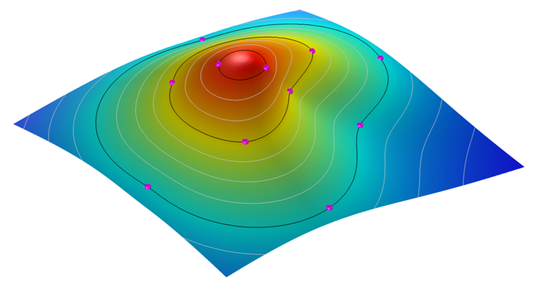
Рис. 1. Інтерпольована поверхня шляхом використання RBF. URL: https://cdn.comsol.com/wordpress/2016/03/Surface-interpolation.png (дата звернення: 16.03.2026).
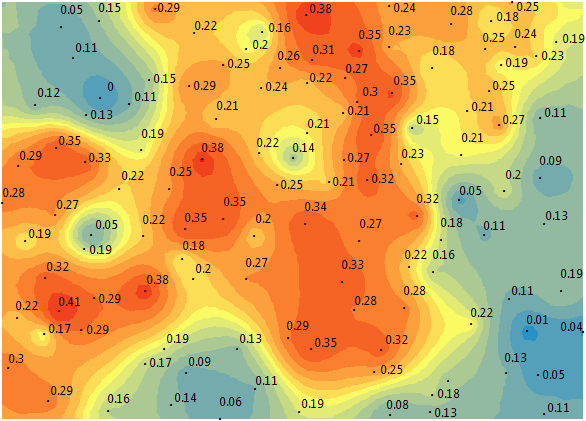
Рис. 2. Інтерпольована поверхня шляхом використання Kriging з обчисленою похибкою. URL: https://gisgeography.com/wp-content/uploads/2017/01/kriging-results.png (дата звернення: 17.03.2026).
Бубняк І., Ціхонь С., Ціхонь Т., Лущак У., Бігун М. Методи побудови 3D моделей геологічних тіл (на прикладі родовища Сауляк, Закарпаття). Вісник Львівського університету. Серія геологічна. 2023. Вип. 37. С. 97
Прокопенко О., Баряцька Н., Зацерковний В. (2024). Порівняння алгоритмів каркасного та неявного геологічного моделювання в Micromine. Географічний часопис Волинського національного університету імені Лесі Українки» 4, 151–160.


